Radio crackles – “you’re smoking, your brakes are on fire!”
Downshift – engine screams
“We’re still going 50 I think” quick mental conversion, the speedo reads in km/h.
Angus’ body sways on the steep descent. I make the smallest possible corrective movements to keep us steady.
“How far do we have to the bottom?”
Tour bus roars past on the left
Ant – working the GPS, “about 7 miles”
Pumping brakes with diminishing results.
“They’re fading, we’re heavy. Tell me this road stays straight – I’m afraid we’ll roll”
“Looks like a few gentle turns and a bigger one at the bottom”
More cars pass, scowling at us with disgust that our micro convoy has momentarily delayed their arrival in oblivion.
Windshield steams up – from the outside
“Is that brake smoke?”
“Nope that’s steam”
“Shit! you’ve got to be fucking kidding me right now.”
Temperature gauge climbs to the top, I grab for the radio
“Dan – our temp is about to hit the red line, we need to get off the road”
“Do you think we blew out a hose or the radiator?”
“I think we need to get off the road”
“How far? I can’t see any real shoulder (ahead). I don’t see us stopping before the bottom (of the valley)”
“I think we only have another mile or two, the road levels out”
“I’ll try to pump the brakes some more – they may have cooled off ” – which lasted about 3-4 pumps.
The road levels out, I drop the defender out of gear and coast, pumping marshmallow brakes along the way. The distance to the parking lot can’t close fast enough. The thermometer hangs just below the red line.
The old landrover limps passed gas pumps and a troop of dawdling German tourists. I shut off the engine. Coolant is belching from under the left wing, pooling up on the pavement. We lift the bonnet to help dump heat. The reservoir is as dry as the desert floor. Danny, Ant, and I step back for a moment and stare. The ambient temp is 105. F-18s are dogfighting overhead. Echoing shockwaves make it difficult to think or hear. Sweat evaporates before it can flop. My throat is dry and stingy from my hangover, the stress of the past 15 minutes, and now furnace air. Anxiety reaches the redline same as the thermometer. In my mind, all I can think is ‘We’re done and we’re towing Angus back home on the first day’. FUCK.
Six Months Earlier
A long summer and autumn of excursions came to a close. The first snows started to fly in the Northern Sierra Nevada. Gear had been decommissioned for the season. Gandalf reconfigured for winter. Angus tucked away in a heated garage.
It had been at least 12 years since I had last spoken to my friend Anthony (Ant). He (Ant) was the first person I set out with on repeated adventures after moving away from home. Our terrestrial journeys backpacking through the Adirondacks and the White Mountains or sailing the New England coast seldom ended without some element of catastrophe. Often calamity was directly caused by a combined youthful bravado and shallow experience. Disaster averted by sheer, dumb luck.
So, when I called Ant for no other reason than just to say “Hey”, the discussion eventually (predictably) returned to “Do you still go on any of those epic trips?” The subsequent conversation propagated into a deep discussion of the Overland Expo West and how it repeatedly served as a springboard into extended desert explorations in Arizona and Utah. We talked about the loose plans for May 2019 as another potential deep push into more remote terrain that we’d never been to before.
“How long do you think you’ll go?” “2-3 weeks, depending…” “OK, let me call you back.” That’s where we left it. Eight weeks later the text conversation played out something close to: ‘Still going in May?’ ‘Yup.’ ‘I’m in.’
Full disclosure: Wildwood Expedition, one component of a larger coordinated effort, is a pipedream in motion. [We’re] Working to grow it into an opportunity that I/we can one day completely immerse and support ourselves in. What is important here is, that for now, we all have day jobs to keep the wheels turning. Overlanding and sharing our journey are more than a weekend warrior pursuit, but for many reasons, the opportunity to cast off the last of the common socio-economic constraints is still beyond our grasp.
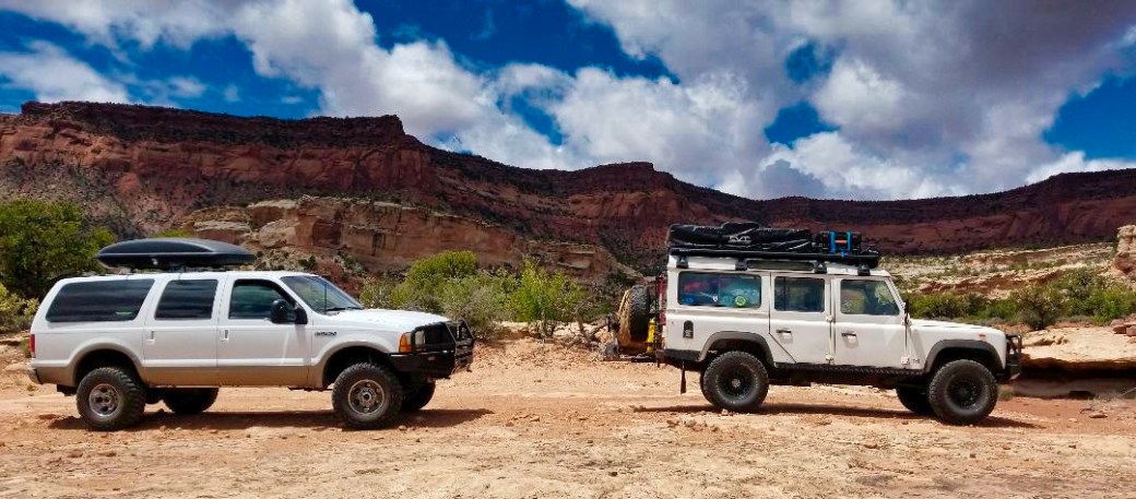
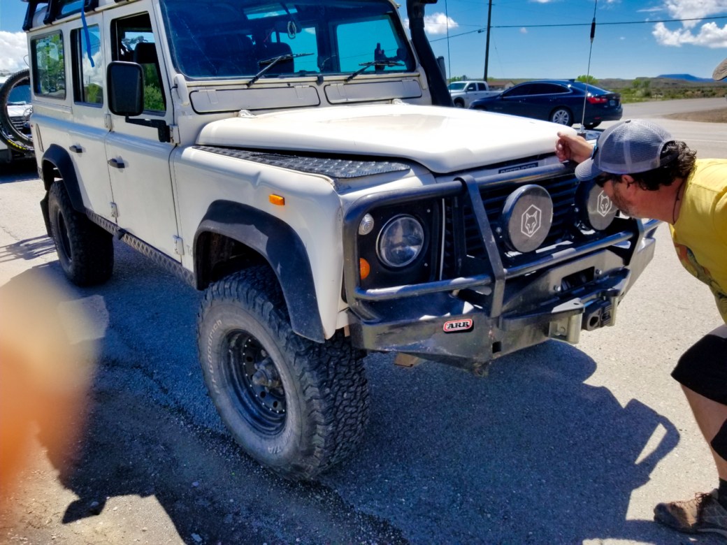
A good amount of time over the winter had been invested in repairing and upgrading components of the Landy (some by us, but most of it by the professionals). We’d mounted a rooftop tent and sliding refrigerator. Conceiving everything we wanted in a dedicated overland rig and acting on what we could afford. We took the show on the road for a shakedown trip to make sure that gear had found its way to the proper spot in the vehicle.
Ant was due to arrive in Reno early in the week leading up to the OEW. In the days prior to departure with best intentions for a smooth getaway in mind, we had Angus loaded, running on shore power, and ready to roll.
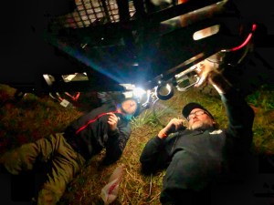
There is always a last-minute project, or fix, or reconfiguration to get us on our way. True to form, this time we found ourselves mounting up Danny’s new (new to him) winch. Last light had faded when the final bolts were in place. Not a completed install but good enough that it wasn’t going to drop on the highway en route to Flagstaff.
Departure day, for me, is always an adrenaline-fueled bag of closeout/sign out/check out (as per aforenoted day job), last minute prep, and barely containable excitement. Pulling away without Bear left a seat empty in my mind. I’ll make it up to him for sure once school ends for the year.
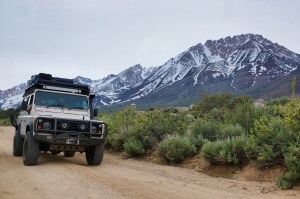
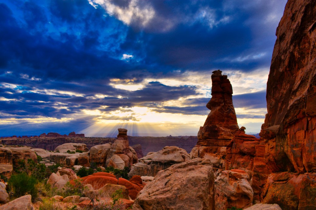
- Sliding down the east side towards a destination unbound. Credit: Anthony Vigliotti
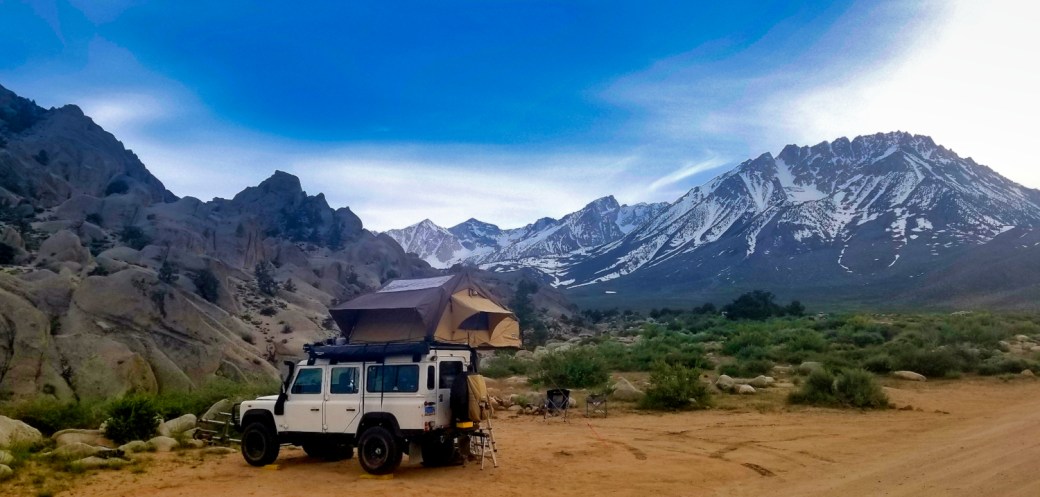
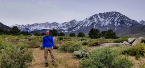
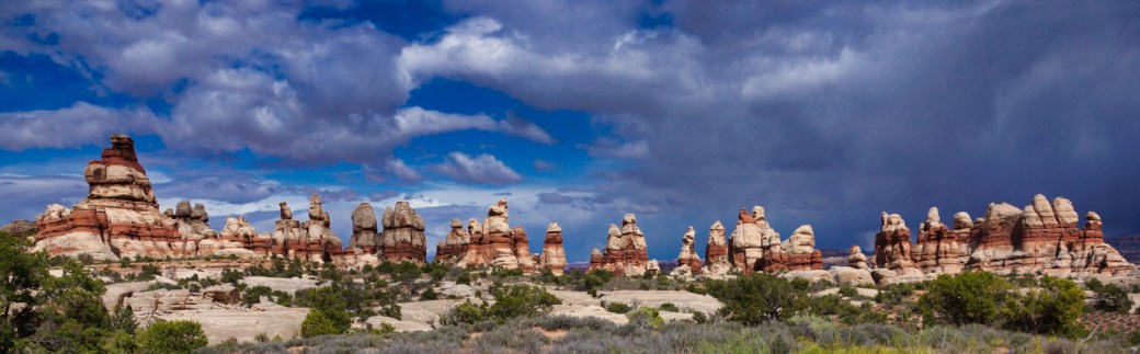
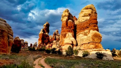
The eastern slope of the Sierra is magical. Traveling in its shadow is therapeutic. Angst peels away over each summit until you arrive at the start of your journey. In that sense, our journey started in the Buttermilks. A familiar place of enormous positive energy.
The Sierra Crest here forms a colosseum of 13,000ft peaks that, silhouetted by the setting sun, cast blanketing shadows across the valley floor. Inbound weather generated a stiff Easterly wind that carried the sweet smell of sagebrush in spring bloom and serenaded our camp with a dull chorus as it whistled through the weathered outposts of granite dotting the high desert. A fire burned late into the evening. Copious libation fueled a raucous reunion.
The sun rose on my hangover well before even the sage grouse could drag ass out of the nest. A wiser man may have recognized that this was a troublesome omen for what would become a very hard and challenging travel day.
Dan linked up with us in town for coffee. We laid out our maps and agreed to take the paved route through Death Valley and Las Vegas. Our goal was to reach Williams or even Flagstaff by nightfall.
The wind had increased substantially overnight; gusts became a sustained gale. It’s well known that defenders have all the aerodynamic efficiencies of a brick and that engine performance could be better. Angus struggled. I thought that I’d been pretty weight conscious when selecting what made the cut equipment wise. We were loaded but not overloaded, paying close attention to weight distribution within the vehicle. Entering Death Valley, we were pushed around by winds and labored to climb more than expected. The more I pressed Angus to keep a healthy pace the less performance we seemed to receive.
Passing over the first set of hills the environment shifts from high desert to wasteland. With all the beauty that comes with the absence of water and harsh geological landscape.
Less than 24hrs of travel and Ant called out how we had already seen so much and changed several climates from coniferous forest to alpine, to chaparral, to arid desert. At several times we made photo-stops along the descent to Panamint Springs, absent were the olfactory blooms of the sagebrush replaced with, well nothing. Light, warm breezes whisked my moppy head in almost complete silence. Swallows and Cooper’s Hawk strafed the cliff faces for prey. Nappy grasses poked from the crags. Angus followed the sinuous ribbon of asphalt to the valley floor.
Climbing out of Panamint Springs to Towne Pass was the hardest I’d seen the landrover grind. Temps rose inside and outside. The road only grew steeper as we ascended towards the summit. I wanted more than anything to give our tired horse rest and hoped that the toughest was behind us. Road construction was underway at the top of the pass which halted our progress for a half hour. This welcomed respite was only momentary. Once traffic was permitted to continue, we found the road pitching down similarly to what we had climbed. I tried to hold the Landy in a controlled descent as slow as possible, but it was in the first mile the brakes faded. Dan hailed us on the radio from behind, our brakes were smoking and on fire. The situation started coming apart. We started a long, scary ride to the bottom.
Coolant continued to drain from the heater box against the bulkhead. Ok, blown heater matrix, not the worst possible scenario. Engine condition remained unknown. Too hot to touch just yet. I went to find the restroom and calm some worn nerves as the realism of what we’d avoided was sinking in. My place was in line behind the group of dawdling tourists.
Why does it take some people, regardless of gender or age, 10 minutes to take a fucking piss? Are American gas station shitters that comforting? Never have I had to wait so long just to take a leak. I quietly began to allocate blame for my deteriorating mood to their sluggishness.
When I returned to the Landy, tools had been spread across the asphalt, Dan and Ant were already busy pulling hoses to bypass the heater box. A neon green puddle had collected. They were confident. I was skeptical and less than happy. If this didn’t work, if the engine was damaged or couldn’t hold temperature, our next step would be to try to trailer Angus back home, swap as much gear to Gandalf as we could, and start over. Would Angus be ‘mostly capable’ and we’d limp through the next few weeks on the road? Is this nothing more than a nuisance hiccup in our day?
Once the bypass was buttoned up, we refilled the radiator with spare coolant that we had on hand. Luckily it turned out that we’d only drained a gallon or so. The engine cranked right over, and the temp rose slightly higher than normal but within an acceptable range. This made logical sense with the loss of the heater core. No other fluids leaking; keeping fingers crossed it seemed that the damage had been contained.
We tossed some kitty litter on the puddle and swept up as best we could. While we readied ourselves a dust devil spun up along our path. Ant filmed the mini cyclone while my expletive-laden soliloquy continued to flow unimpeded by our improving situation.
Engine temp held stable and the bypass hose didn’t leak so we considered ourselves lucky. Continued shifting winds increased throughout the day added excessive body roll making driving more like a wrestling match. The effect of wind combined with load weight resulted in a slog of a drive. Engine power, or lack thereof, seemed to be – not improving. We blamed it on the wind, at least I did because I couldn’t manage any more mechanical issues.
The remainder of the day’s drive, through Las Vegas, across Hoover Dam and traversing Northern Arizona seemed to be dominated with an abundance of cat-like alertness behind the wheel. Ant was getting tired of hearing me talk about it. I started to wonder if he was second-guessing the decision to make this trip. Arrival at the OEW when the vehicles could be parked for a few days and the health of the landrover could be re-evaluated loomed large on my mind. If it is true that ‘adventure doesn’t start until something goes wrong’, then the adventure was on.
Night had fallen by the time we’d reached Williams. This was going to be our destination for the day. It had been almost 12 hours on the road from Bishop. The day had left us weary, and hungry, and thirsty, and a bit absent-minded because I must have rolled right through a stop sign. Flashing red and blue in the rearview added to our list of wins. Williams is a historical Route 66 town that has seen its share of car and motorcycle rallies. Guessing from the steel bars on all the bars in town, rallies and revelry came as a package deal. This cop wasn’t about to tolerate any shit from us. The officer was perplexed by the right-hand drive and after running a background check kind enough to see us on our way without a ticket. He offered us some advice on the best place to make camp for the night. Directions we followed immediately after we finished filling ourselves at Grand Canyon Brewing Co. with a much-needed meal and beer(s). The camp turned out to be a generic US Forest Service square of pavement in the woods complete with a lake that didn’t permit swimming.
Sleep passed that night in 30- or 40-minute increments. I found myself ruminating in between nightmares of uncontrollable defender roll-overs. By morning I’d replayed the incident in Death Valley so many times that the only possible conclusion was that luck over skill had played into the outcome that could have easily ended catastrophically.
With sun up, a cool breeze, and no one interested in exploring the esoteric implications of the previous day’s events, we instead satisfied a burning desire for craftily prepared java. An easy find in a town that caters to tourists. Our serendipitous discovery of a purveyor of the artisanal beverage was soured by a shortish fat guy sporting semi shabby clothes over a complexion of Elmer’s glue. He queued in front of us. Dan and I stared down at his rusty hair overloaded with product and paired with the close-trimmed beard of someone who finds themselves stuffed in a cubicle farm devoid of fresh air or natural light 9-5 Monday through Friday. The perplexing little creature glanced up from his iPhone, slipped it into his man-purse, and dragged a coffee and burrito order out to a convoluted 5-minute condescending diatribe. He then, in stunning self-centered dominance-behavior, proceeded to plant himself in front the of the cash register, arms folded, and waited for his order to be filled, effectively preventing the rest of the line from placing their own. As spectators observing this dynamic, while operating from our own personal places of caffeine addiction, the queue was left hovering somewhere between social norms bewilderment and urge-to-kill.
Cooler heads prevailed. Caffeine receptors satiated. A Zen air settled like ground fog amongst the patrons. The universe re-aligned. Team Wildwood hit the road. Flagstaff is only a short drive east from Williams.
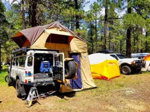
Arrival at The Overland Expo West 2019 turned out to be super easy despite some perceived challenges. Vehicles were parked and buffoonery commenced. I think this year we were much better prepared – expectation-wise. I thought that we were more engaged with the program. Our camp neighbors absolutely made a difference, fantastic people. The air punctuated with the freshness of the pines blended with an unmistakable signature of horse stables.


Settled comfortably into camp there was no better time to pull the bumper off the excursion for alignment and wiring adjustments.
Thrice we removed, manipulated, re-mounted before achieving optimal positioning. Tasks that became more complicated as daylight faded and pint consumption increased.
2019 was our best expo, best experience, and the worst weather we’ve encountered so far. In hindsight, perhaps we should have stuck around through Sunday, but we had a lot of circles on our map.
Beer, food, fuel, laundry, shower; check, check, check, check, and check. Conceivably the next substantial resupply opportunity could be five days out. Danny needed to take care of some business in Denver for a few days. Lightning Dave pointed the Ghost south towards Phoenix. Ant and I had a rough plan and several days to roam before our backcountry permit activated.
Neither Ant nor I had a lot of experience exploring the ruins of southwestern cultures so on Dave’s recommendations we agreed that we’d be stopping at as many sites as we could along our journey. With that, our path turned north for a short while until we found ourselves at the Wukoki and Wupatki Pueblos.
The peoples of the Wupatki area, or Sinagua, are believed to be an aggregate culture of Cohonina, Kayenta Anasazi, and Hopi traditions who settled this high desert plateau. They existed primarily upon trade with those cultures while managing to maintain a marginal agricultural existence. The volcanic activity of the immediate area between 1040 and 1100 is presumed to have driven most of the inhabitants of these pueblos to new homes by 1250. Those migrants integrated with other evolving cultures including the Zuni, Hopi, and Navajo.
We wandered through the Wukoki Pueblo snapping artistic, well-composed photos of the masonry walls, sapphire sky, and snowcapped mountains. A stark white couple comprised of a small skinny man and a large fat woman dressed as if they had been on safari seemed to wander into frame for almost every shot. A cool breeze prevented the rocks from getting hot and native lizards from sunning themselves.


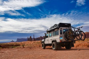
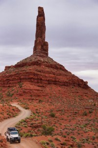
It felt like time to put some miles behind us. Our path turned east across the northern tier of Arizona. We let Angus move as fast as he wanted to go because slow is smooth and smooth is fast. We covered good ground and he didn’t give us any grief. The landscape transitioned into the lands of the red sandstone and I settled in this environment. I have found an affinity to the red sandstone of the desert.
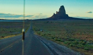
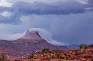
Shortly north of Kayenta, the Navajo sacred mountain Agathla rises from the desert. Out of place geologically, the black monolith contrasts against the rusty surroundings. The formation is the remains of a volcano that has eroded away over the centuries leaving only the ‘lava plug’ to fill the negative space below the caldera and a black apron where the ghost mountain’s footprint existed.
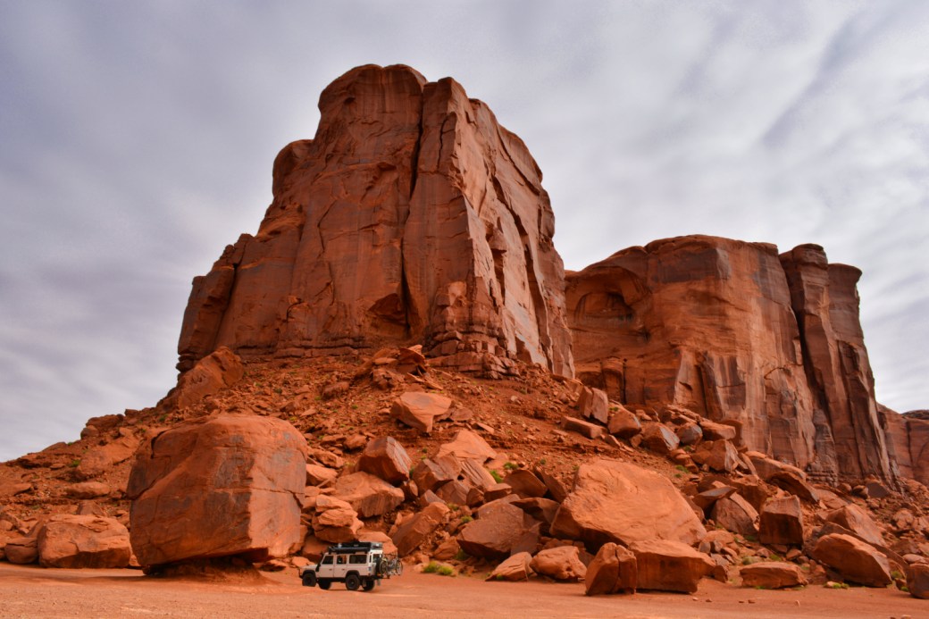
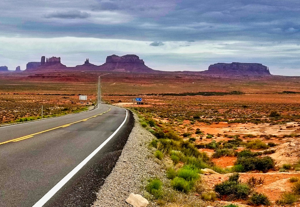
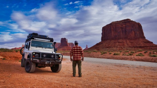
The sun had just set behind the incoming cold front when we arrived in the sovereign Navajo Nation. As we crested the ridge to the (eh hem) parking lot, the full moon had barely risen above the horizon creating a spotlight backdrop for the buttes of Monument Valley.
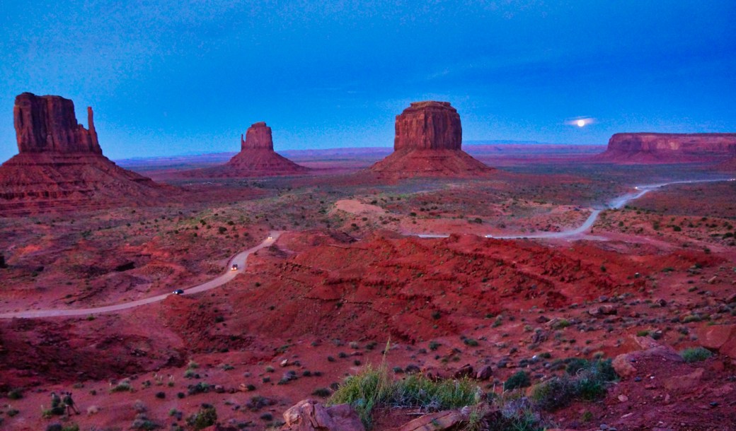
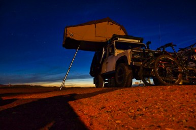
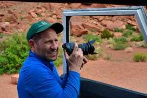
Ant was out of the truck with his camera bag and tripod in a flash. I stuffed Angus in a spot and followed suit. After clicking off a few dozen shots I made way to secure a square of dirt for the evening leaving Ant to work some hot angles. Our camp won’t go down in Wildwood history as one of the best, but it certainly was unique for its surroundings.
The red color of the sandstone is indicative of the Cutler formation during the Permian period (roughly 160 million years ago) The material of this formation is the result of collected shoreline material dating back 570 million years when the Colorado plateau lay beneath the Gulf of Mexico prior to the uplift of the Rocky Mountains. In 1958 the Navajo Nation Council established Monument Valley. The Tribal Park covers almost 92,000 acres across Arizona and Utah.
Overnight the approaching cold front passed through. Exhaustion from the day’s travels buried us so deeply in sleep that we didn’t notice the flapping of the tent through the night. I cooked up some breakie while Ant made the daily engine inspection of the Landy to ensure that the coolant routing was intact.
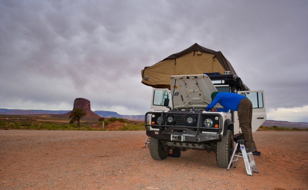
He discovered that the vacuum line servicing the turbo wastegate had been severed by rubbing against the tail of a hose clamp. Also, the hose connecting the air cleaner to the turbo was roached. The mystery of the poor engine performance now had (at least) one likely culprit. There was a high likelihood that the turbo had been dumping the entire trip and not providing us any benefit. Repairs were made to both lines sufficient to get us through the next week. Our intent was to log a good bit of mileage off-road so keeping the turbo from ingesting grit was time well spent.
To make the best of early morning light for a photographic mission we made fast our gear and hastened our departure from camp. A surreal descent into the valley as walls grew around us and time faded behind us. Mostly alone on the valley road, we meandered amongst mesas, only brought back to the 21st century when another vehicle entered view. Angus was strategically positioned for a few photos along the route. Otherwise, we poked around the trail where it was clearly acceptable. The paradoxical nature of this inhospitable, angular, hard landscape is the warm, peaceful and welcoming spirit that it invokes.


When I say “warm” it is both a spiritual and a thermal statement. To put the latter in context it is important to note that we base ourselves in an alpine environment in one of the snowiest places in North America. This year (2018-2019), winter spanned 206 days and we received 719 inches (59.91ft) of snow. Any moderate temperatures where I can go without down puffy, let alone put on shorts, is a hot day for me. I wear winter skin year-round. It regularly snows to a tall man’s ass.
The early morning gamble paid off. A congo-line of late sleeping visitors entered the valley as we climbed out. Angus receives a lot of thumbs-up from other drivers no matter where he goes. Since our departure, I’ve had to explain his origins and pedigree several times.
The turbo hose repair made a difference, but not a world of difference. There was still probably a bit of vacuum leakage that we’d need to get a new section of hose. Regardless, the performance was better – for sure.
Passing through the town of Mexican Hat, we dined at a Mexican restaurant, where they were not serving Mexican cuisine. Confounding. I had a hamburger. Lunch was delicious. I know a good burger.
Valley of the Gods lives up to its name. Less majestic than Monument Valley, it is equally awe-inspiring and less restrictive. The road through the valley is a graded dirt track. One is welcome to roam with impunity across the terrain (on foot). Camp where you will (within reason). The spirit of freedom entwines with the rugged landscape. The uniqueness of the desert jewel hasn’t been lost on its visitors. Respect for its features is evident. Without endless postings or trash receptacles, we didn’t notice random 2-tracks across the desert or find piles of trash in obvious camp spots. Ant and I explored several of the epic camp opportunities, but it was early in the afternoon and there was no reason not to press on. In hindsight, hunkering down might have been a better decision.


So up the Moki Dugway we drove onto the next step of the Colorado Plateau. The Moki Dugway is a gravel section within the paved highway 261. The road is carved into the cliff face of Cedar Mesa. Its ascent (or descent) is an 11% grade over three miles that covers 1200 vertical feet. A half-dozen switchbacks claw up the face. In that way, it resembles the Shaffer trail in Canyonlands National Park, yet the switchbacks are wide enough that K-turns are not required. The driver in a Moki Dugway passage enjoys a pucker factor of 8-out-of-10 while the passenger gets a 9.6 experience. Ant spoke in low, stressed tones between snapping pics. I was gripped, mostly silent, and over cautious. I need to learn to be a better communicator.
Intermittent rain spotted the windshield as we traveled north along the shoulder of the mesa. Light terrain relief made for a more relaxed drive.
Natural Bridges National Monument was within reasonable striking distance and the most logical destination for the night. There is an established camp area and with that a good chance for water and facilities. We were not the only travelers with this plan. The camp was full. Park Rangers directed us to some backcountry dispersed camping where we were free to stay for as long as we wish, albeit without water or toilet. The clouds grew tighter and darker. The warmth of the day began to slip away. All signs pointed to a wet cold night ahead.
On this journey thus far we had experienced rain, snow, below freezing temps, or a combination thereof daily. Not my prior experience nor expectation for Arizona and Utah for this time of year. Angus now sans heat did not improve the situation.
Following the Ranger’s directions, we poked around the mountainside as the rain ratcheted up. With weather inbound we sought space at the lowest altitude available, sheltered by juniper, and away from a wash if possible. A hastily set camp was in order. Prior occupants of this little corner had built up a fire ring. I improved the ring with stones from around camp while Ant, forever the Eagle Scout, maniacally set to chopping downed wood for a fire.
Temps hovered in the low 40’s. Rain passed in varying bands of intensity into the evening. The ground beneath our feet started a transformation into slick sticky mud. Solid cloud-deck to the horizon offered little hope of ending precipitation. For us, now cold and wet, the thought of deploying more gear in the rain, only to have to manage it in the morning was a particularly unappealing proposition.
The rain did lighten up around dusk. We lit a feel-good fire to drive the chill away. A campfire that includes juniper in the mix is special. Burning juniper has a unique scent, much like incense. It wards off things that go bump and settles over the camp like a calming blanket. We made the best of our damp little camp, huddled around our fire, and warmed ourselves from within with hot Chef-Boyardee Beefaroni straight from the can. Music played and too many beers were consumed. The rain eventually returned. Instead of grappling with more weather it seemed smarter to settle into the RTT, high and dry for the night.
Temps fell significantly overnight. I can’t speak for Ant, but it was the most uncomfortable I’ve been in some time. At first light when I climbed down from Angus’ roof everything around us was encased in ice. The tent, the trees. Icicles hung from the Landy. Our groover was set up 50 yards north of our camp. Ice needed to be broken off that as well for the morning constitutional. Invigorating indeed! The cold night was over, and the sun was rising over Bear Ears.
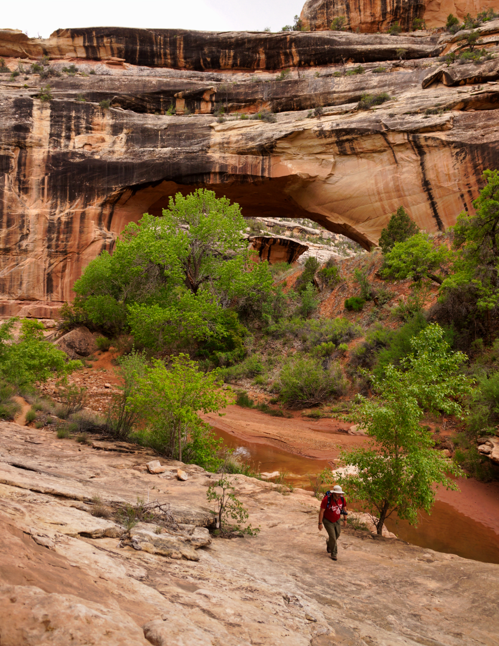
From one of our many stops while exploring the loop road within Natural Bridges we could see the Horse Collar Anasazi Cliff Ruins far below. The sun shone brightly and warm(ish) temps returned. A shoe-leather heel-toe adventure to make a closer inspection is precisely what Ant and I were all about.
The region surrounding Natural Bridges is comprised of crossbedded white sandstone. Over millions of years of uplift from sea level, the impact of wind and water sculpting the sandstone has left river canyons, natural bridges, and caves.


The trail made a steep descent from the rim to the streambed. Once again, we had a park to ourselves. Free to roam the floor of the canyon amongst cottonwood, willow, and box elder. Scattered and sun-bleached bones of deer served as evidence that coyote reign as apex predators here.
Desert varnish contrasts starkly against the white sandstone. Patterns of weather stood out most predominantly from the ‘freshest’ eroded faces beneath the Kachina Bridge.
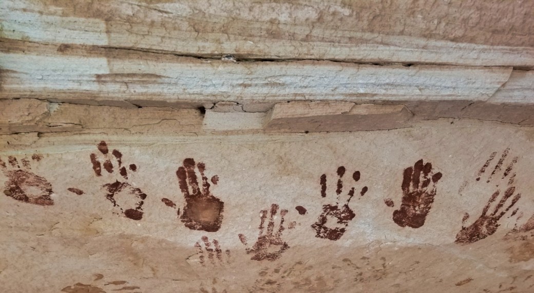
The lower rock face beneath the ruins yields few clues to its location. The climb is steep and exposed. The reward is an un-interpreted, un-spoiled, un-violated encounter with the past. The only suggestion of modern intervention is a modest sign placed near the ruin gently asking visitors to look but not touch.


The ruins span two large overhangs in the cliff face. Each building is in various stages of disintegration. The construction spans stone & masonry to wood and mud-stucco. Bits of pottery, flakes of stone tools, and remains of corn cobs litter the site. In the largest structure, adjacent to the horse collar granaries, remains a circular fire pit in the center of the room beneath a crumbling ceiling of wood lathe and mud stucco.


To have the opportunity to explore this place without the interaction of others is a gift. During drier, warmer weather I would not expect to have this opportunity. Absent the incessant babble of others or insensitivity of spacial interaction allowed the personal play space to stop, listen, watch, wonder.
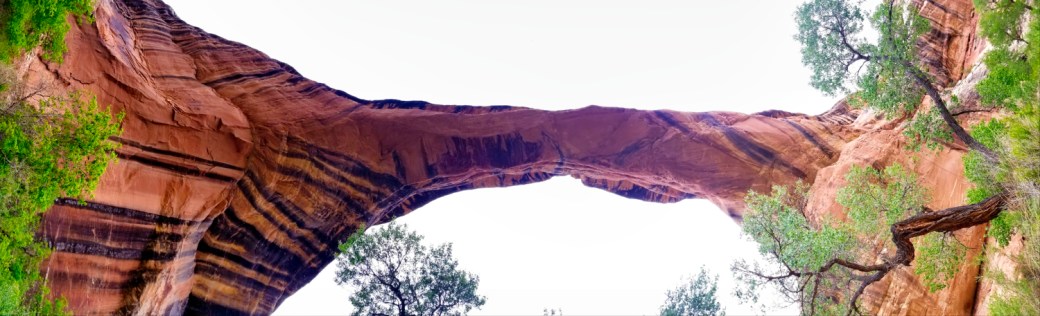
Our paths crossed some other hikers as we departed. They were dressed for dry summer weather and carried few supplies. Ant and I continued our hike eastward to another bridge we had seen from above. We reached the Sipapu bridge in only a few minutes. As we clicked off shots from underneath, we noted that the sky had refilled with clouds and a constant colder breeze had kicked up. A good sign that weather was on its way.
Ant had the sense of mind to call off the mission and “beat feet” back to the trailhead. We were equipped, but not equipped for an overnight stay in the canyon in harsh conditions. A couple we passed under the bridge offered to drive us back to our vehicle if we wanted to follow them straight up the canyon. We knew how far we had to go and politely declined their offer. This was a mistake.
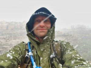
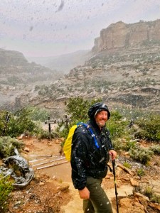
The wind continued to build, the sky became darker, and the temperature was dropping rapidly. A light rain began before we’d made 1/3 mile. Not taking chances we donned what waterproof gear we had. Our base layers were cotton, less than ideal for the condition. As I glanced up at the rim it was an all-too-familiar sight, and it wasn’t rain. “Ant, we’re in for a snowy hike”. “Less talk, more walk”.
Roughly three miles to Angus should have taken us about an hour. We moved with purpose. About one mile to go we were thoroughly soaked through our clothes. The snowfall had increased. The temperature had dropped to around 29 degrees.
Rain concentrated into streams and cascaded off the ledges. Showers poured from the hanging gardens. The creek volume and velocity had increased. We now found ourselves in that very dangerous situation of being cold, wet, in adverse weather, and now other environmental conditions created additional hazards. All the factors that contribute to hikers getting caught with hypothermia were now firmly in place. A keen eye and ear were kept open for the tell-tale signs of a flash flood that would send us scrambling up the canyon walls.
The last mile in the streambed was the hardest. I didn’t tell Ant, but the cold was starting to wear on me. My core was getting cold. He is a seasoned scout leader. I’m certain that he picked up on my condition. I was fortunate to have him as a partner on this one. Soaked and frozen cotton pants gained at least an additional ten pounds of water weight, further slowing the hike out.
While it was the most physically demanding part of the day, the steep climb back up the cliff wall was by far the brightest part thus far. A ranger clearing the trail of hikers crossed our path and joined us for the remainder of our climb out. Angus has never looked as good as it did at the end of that hike. The rim had accumulated a good three inches.
The ranger station made for a warm and dry oasis in an otherwise cold and wet desert. Getting into the warmest gear we had in possession including hats and gloves became the immediate priority. Finding accommodations was second. In our planning, we did not prepare for extended cold and wet conditions. The weather had surpassed our equipment’s capabilities.
The Rangers found themselves with a full house. The few hikers and all the other tourists had sought shelter in the interpretive center. Not one of those folks were interested in the history, geology, or cultural heritage of the park. Everyone just wanted to be warm. We asked for some advice about what our next step should be. We had three options, Blanding (in the wrong direction), Hanksville (overshooting where we wanted to end up), and Hite (best option but questionable facilities for our needs). The ranger made a few calls and came back to us about 20 minutes later with a phone number. She informed us that Hite was where we wanted to be.
Off we ventured to the Hite outpost on the eastern edge of Lake Powell. Hite once saw more traffic when the lake was higher and it sat at the edge of the water. Decades of arguably poor water resource management by the Federal Bureau of Reclamation has left the Hite recreation area at the bank of the Colorado River a ghost town.
In recent years the National Park Service has all but abandoned its ranger station there despite a sparkling new facility. Several concession operators of the Hite facility have given up and closed shop. As of this year, 2019, the owners of the Ticaboo Lodge (downriver into Lake Powell) were awarded the concessionaire contract to operate Hite Outpost and re-open the facility. Getting back to Hite’s former services involved restoring the campground, opening the general store – including vehicle fuel, some form of efficiency lodging, and eventually guided tours and equipment rentals.
Anthony and Maggie, a young couple from Salt Lake City, were hired to rebuild the business and manage Hite Outpost. The (surprisingly enjoyable) 90-minute drive from Natural Bridges to Hite brought us to lower altitude, warmer temperature, and less precipitation. The landscape transformed from the white sandstone of the high plateau back to the red rocks we expected in canyon country.
When we met them in the outpost, their greeting was genuinely welcoming. They were excited that we were interested in renting the RV facilities that they had just finished setting up. It seemed that they hadn’t had too many visitors this season. A little leery of RV rentals we had a few questions:
Got Heat? – yes.
Electricity? – yes.
Hot showers? – yes.
Flush toilets? – yes.
Kitchen? – yes, fully stocked.
Sold. – Don’t you want to know our nightly rate?
I guess.
It may have been midafternoon by the time Anthony had set us up. It didn’t matter. We were due for an easy go at it. I unpacked pantry boxes and emptied the trash from Angus. Ant strung up a clothesline and started hanging our gear to dry. Hot shower, warm room, a hot meal, made us almost human again. Every battery-operated device was set up for recharge. Well outside of cell phone range, all ‘we’re fine’ communication with the families was conducted via satellite text. A fabulous night’s sleep followed.
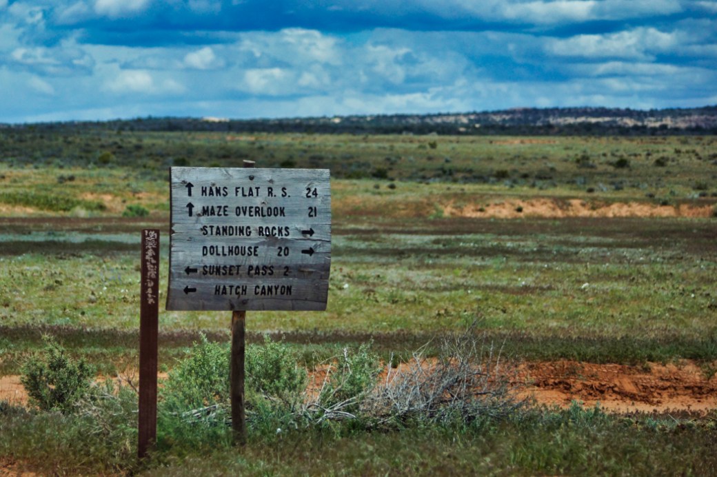
The next goal was our expedition’s jewel. We had been granted a backcountry permit to enter the Maze, a remote district of Canyonland National Park, and make our way to the most remote point of the park called the Dollhouse.
Trails in the National Park system are rated on a 0-4 scale. Other trails that I have traveled in the past have been straight forward and of low risk. For example, the White Rim trail in the Island of the Sky district of Canyonlands is rated 1.0. Our intended route through the Maze is rated 3.8. Concern over Angus’ capability in this terrain and worries over breakage had been slowly building over the past week. Our incident in Death Valley didn’t help assuage my fears. Danny was expected to rejoin us in the morning. We had done our research. Studied maps, watched YouTube videos of others driving the toughest sections. It didn’t seem all that complicated a feat given all the available empirical evidence. I found myself looking for reasons to turn back and not risk further damage to the Landy.
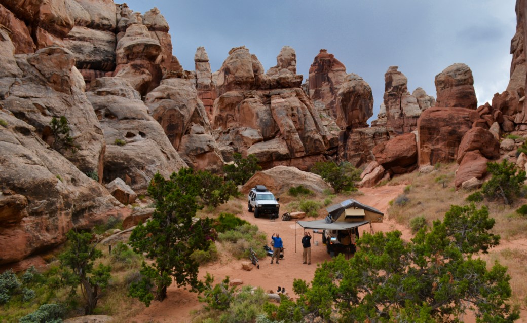
As morning light filled the corners of the canyon I was astonished at our surroundings. This safe harbor we’d pulled into as overland refugees is as picturesque and energetic as any of our travels. Danny was a few hours from joining us. We could take time sorting and stowing gear. Sipping coffee in warming rays. Poking around the cliff walls behind our camp.
Dan packed his excursion and turned west from Denver at 9pm the previous night. The direct route from Denver to Hite is 450 miles. We expected Dan’s arrival between 3-4am. The snow that hammered Ant and I hiking the previous day moved east and met Dan as he climbed the continental divide. Highway conditions deteriorated to complete white-out blizzard. Heavy wet snow accumulated on the roadway bringing progress close to a white-knuckle pace. The slow grind on the downhill western slope of the Rockies continued to almost Grand-Junction. Dan joined us at Hite shortly before 10am, thirteen hours after he’d started driving.
Weather forecast unsettled weather several days out. Park Rangers had cautioned that the trail can become in-passible during extended rain and snow events. The team shared strong agreement on the importance of keeping watch on the upslope stream flows. The consequences of an ill-timed wash crossing could be devastating.
To reach the Maze from Hite requires one to cross through Glen Canyon National Recreation Area. The trail across the area is rated as easy. Most of it is an improved gravel road the meanders through stunning canyon country terrain beneath rust and ivory stratified sandstone cliffs.
Extended seasonal rains lengthened the sagebrush bloom filling the air with the same sweet aroma that we’d enjoyed in the Buttermilks. The mellowness of the drive is opportune for covering the first 24 or so miles of the trail quickly. We noted several unmarked intersections in Glen Canyon that did not appear on any of our maps. Confused, we choose the path most traveled and hoped for the best. Our route to the dollhouse was estimated at 52.5 miles from Hite. Crossing into the Maze District proper we were 20 miles from our destination.
The first and most heroic trail obstacles lay immediately east of Teapot rock. Our guidebook and the GPS were having a bit of disagreement regarding its exact location. Ant and I identified several teapot looking rocks. Our interpretation of teapot shape is different than others.


True to guidebook description, the first turn past the “Teapot” is where the driving begins. Angus was dropped into low range for the first time under my ownership. The test of his mettle commenced. Over the first few challenges, my apprehensions were replaced with grins. Focus was on point. Minor driver miscalculations aside, Angus walked over every boulder, step-up, outcrop, and slab with the stability of a spider.
Danny didn’t seem gripped at all. His heavily modified excursion supreme rolls over everything whilst he sips coffee and checks email. I suppose there were a few tight cruxes that needed a bit of eyeballing, but he seemed quite relaxed in comparison.

The rock-crawliness of the trail settles roughly 3.5 miles east of Teapot rock. By this point, the focus was centered on the trail and less about the surroundings – at least for me. I relied on Ant to call-out photo ops in the land of standing rocks. At the onset, we balked at the estimated 4-6 hours to run the trail to the dollhouse. The afternoon passed and the estimate was spot on. In all the focus I did note that Ant was a bit trepidatious with my off-road driving. Admittedly, I am no expert, but I do think I can hold my own. I need to practice better communication.
Our journey through canyon country thus far had oriented us with its beauty but over time sensitized our response. Formations that defy logic or when sunlight would break through and reflect the scope of colors in a cliff wall ceased to be car-stopping moments.
The approach to the Dollhouse shook my focused mind away from the trail and rolled almost to a halt. The striation, the color, the structure, the grandeur of the clusters of spires that make up this corner of the earth are unique and dramatic. A place is lost in time. The spirit here is mystical and ancient. Your soul is judged as you enter.
A two-track to our camp weaves its way through the dolls. They close in and huddle behind us. Dollhouse Camp is a small amphitheater surrounded by the dolls 300 degrees. The amphitheater opens to the east as if tiered with spectators of dolls as the entirety of the needles district lays out in mind-expanding vastness, facets, and color.
The intensity of the drive left Danny and I exhausted. What we encountered at the end of the road left us all exhilarated. Predicted unsettled weather began unsettling. Camp was pitched, awnings deployed in preparation for inbound precipitation. Dinner was started. Overstimulated nerves were soothed with ice-cold ales.
The rain didn’t endure for too long and we resumed our explorations individually on foot. The cloud-deck broke up enough for sunset to shine through beneath. Ant returned to camp amped up to show us a portal between the dolls just around the corner. Sparrows and Wren shuttled between the spires. Their song echoing in the amphitheater.
We checked out the portal which offered another window into the needles. The sun had a bit of sky left to cross before it reached the horizon, so we pressed on deeper into the dolls. The path wound through a few slots before opening onto a wide slab outcrop that stood over a sage filled valley crisscrossed with deer paths. We startled a whitetail doe while stepping to the edge. Hiking back to camp we stumbled across a large cave with a high ceiling and a sandy floor. The room was cube-shaped and devoid of evidence of water flowing from any of the recent storms. It had clearly been occupied by humans as there were charcoal and ashes on one side. We didn’t find any petroglyphs, nor could we determine if the occupancy was prehistoric, modern, or both.


Campfires are not permitted in the Maze. The view from the amphitheater served as an ample substitute. Stories and laughter as they always were. Ant tagged the spires. Over to the left was Ketchup Bottle. In front of it was Angry Bird.
Along our travels, we had picked up a hitchhiker that refused to get off at the last stop. The gray field mouse came to the edge of whichever door was open to watch the show and would scurry back into the gear pile before we could coax him out. In a lucky swipe, I got a grip on the little shit and sent him back on his way.
Rain returned during the pre-dawn hours. Downpours quite heavy from time to time. Our CVT tent kept us warm and dry but amplified the fat drops. Rain on tent makes a uniquely identifiable sound. It always reminds me of camp in New Hampshire when I was growing up. My folks would erect a green canvas monster that had no storm fly. If you touched the sides or roof during a rainstorm it would change the alignment of the canvas threads and start to leak.
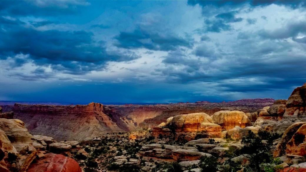
I crept down and wandered around camp in the diurnal light in a clumsy effort to assemble the ingredients of coffee. Victorious in my first attempt I celebrated success by taking the best seat in the house of the amphitheater, where I sat quietly for some time. The sun peeked over the ridgeline behind a wall of broken clouds, piercing the indigo and violet sky with shards of light. As it continued to rise and pour light through gaping holes in the overcast as if a thousand spotlights searching the needles. Red-orange and ivory white of the sandstone began to glow.
In this solitary moment, thoughts drifted with the clouds and wonderment persevered questioning this moment. Was this the penultimate destiny of our journey only to be followed by a circuitous return to the Sierra? If so, then shouldn’t appropriate attention be given to observe all the movements taking place in the surrounding space (be they kinetic or static) to understand their complex interdependent framework, function, and meaning? Or, is this just a lesson in time, a preamble to a deeper purpose yet to reveal itself to the team as we press on to find a semblance of enlightenment down the road?
Dan and Ant were stirring in camp. The cosmic tumblers would need to play themselves out on their own schedule. For now, it was time to fire the galley and get after steak and eggs.
As the camp was broken and vehicles readied to roll, I scouted the wash we had traversed on the way inbound. Water had clearly flowed overnight which meant that the ground could quickly reach satiation and that the potential for flash flooding was very real. We could see several isolated thunderstorms circulating our position, so we had best be on our heads-up game.
In comparison, our return on the trail was much more relaxed and engaging. We didn’t dawdle in any washes. I did my best to practice active communication by calling out our line as we approached every challenge and regularly asked Ant to spot for us.
We moved at a comfortable pace through the land of the standing rocks. Lightening and rain surrounded our position most of the drive, but we never found ourselves in the thick of it. The route traverses a long ridgeline that provided mixed safety. While on one hand, we weren’t susceptible to flash floods, on the other we were exposed on high ground to lightening strike.


Glen Canyon had received significantly more rain than we had deep in the Maze. The relaxed road out had been transformed into a 24-mile mud bath. Heavy, sticky, slick, clay mud bogged our all-terrain treads and sent us sideways several times on the way out.
Frustrated and fatigued, forward progress slowed making our exit a never-ending sideslip. Pavement, with its smooth, consistently reliable, firm surface, felt like nirvana.
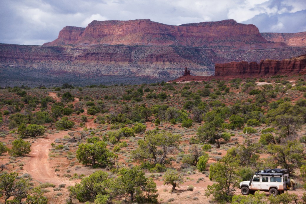
I had initially convinced Dan and Ant that heading off-road into the Bear Ears monument was going to be a great idea. More than any other reason I wanted to explore the regions in support of protecting and restoring the monument to its 1.3-million-acre size.
In December 2016 in the twilight of the Obama Administration, the Bear Ears National Monument was expanded to include many of the spaces that we had explored over the past week. The effort sought to protect the natural and cultural resources from industrial exploitation. The monument would have included Valley of the Gods, Bear Ears Buttes and all the lands from Blanding surrounding Goosenecks State Park, Natural Bridges and bordering with Canyonlands and Glen Canyon areas. This space would be co-managed by the Bureau of Land Management, Ute, Zuni, Navajo, and Hopi Tribes to put some control on the degradation of the region. Although protected, the management arrangement is an arguable improvement at all since federal involvement often ends with all stakeholders losing.
In the year that followed, with campaign promises to keep, lobbyist money flowing like the mighty Mississippi, future campaign funding dangling, and a key local ally in the Governor’s chair, President Trump signed the executive order to reduce Bear Ears and Grand Staircase Escalante Monuments at an unprecedented level beneath their original boundaries. This event essentially declared open season for the mining and timber industries on unspoiled natural preserves. It also lit up a billboard to the world that the Trump administration has a price tag and the United States are for sale.
In response, there was an expected public outcry of injustice. Several groups including the outdoor retail and recreation industry moved their event out of the State of Utah. These mostly symbolic actions had zero effective impact on the situation. At the time of this writing, several lawsuits were challenging the legitimacy of the action at both the state and federal level. Ideally, the plaintiffs can hold the contested terrain in legal stasis until the legislative and executive branches can return to a recognizable level of humanity.
From the highway, at Salvation Knoll, we could look up at the Bear’s Ears. They were buried beneath feet of snow. Bear Ears and Dark Canyon will need to be explored another time. The group’s decision was to press on to the Blanding/Monticello Corridor and re-evaluate our plan. Between Blanding and Monticello, we were able to turn on our cell phones and receive a decent signal for the first time in 5 or 6 days. Family check-ins notwithstanding, time off the grid is glorious and liberating. Informatic isolation greatly contributed to connecting with our surroundings. Of course, the moment we powered up hundreds of queued messages flooded the inbox.
From the cockpit of Angus, the weather didn’t seem like it was going to improve. A stiff cold breeze flowed downslope from Abajo Peak. Towering windmills spun at the edge of town. Broken clouds spit raindrops. The all-knowing internet informed us that unsavory weather was once again on its way. Google stepped in to offer several options for accommodation and sustenance.
Warm, fed, and clean 12 hours later I brushed a bit of accumulated snow from Angus’ windshield. The weathered 200Tdi grumpily cranked up after being left out in the cold. Moab, the promised land, would be sunny, and warm, with endless recreation at our fingertips, lay only an hour north.
In Moab, the rain depressingly persisted. We landed the rigs and strolled soggy streets. It was Thursday, late in May, right before the Memorial Day weekend. Finding a good camp was expected to be a roll of the dice. Between Dan and I, we had a list of good spots. I’d done my homework and had a backup plan if we came up short.
The moment that the rain halted we made for the legendary Sand Flats Rec Area. BLM land that is operated by Grand County. Sand Flats is home to the Slickrock, Porcupine Rim, Whole Enchilada, Lions Back, Hells Revenge, and Fins and Things trails. With supreme luck, we were able to nail down a suitable camp on high ground. Not in our preferred locations, which were occupied. Much of the rec area had deteriorated into muddy tracks, not as gnarly as Glen Canyon, but messy nonetheless. We rode out most of the remaining day under the cover of camp awnings. For a short period, the Moab Brewing Company also provided sanctuary.
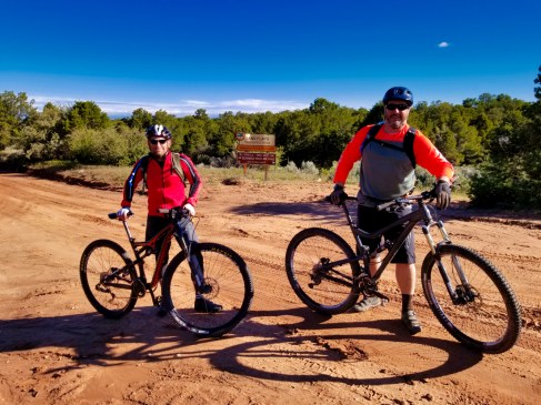
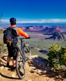
Excitement could barely be contained the following morning when we pulled the bikes off the back of the excursion. Blinding sunshine and a cobalt sky had taken control. Widespread muddiness had given way to perfectly tacky trail conditions. It had been three years since my last rides in Moab. Stoke : Palpable.
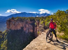
The LPS segment of the Whole Enchilada follows the Porcupine rim skirting Castle Valley beneath the peaks of the Las Sal mountains to the east. Ant is a roadie, I’m out of form and out of shape. We made cautious embarkation and several photo stops. Sunshine makes me happy. Linking up with the Porcupine jeep trail we let the bikes run.
Gravity bested skill in a moment of distraction that sent me over the bars onto the Slickrock. I had the wind knocked out. People of my girth and age hit the ground hard. Arms, wrists, fingers, knees, and ankles still worked. We throttled back and our technique because more cautious. Preservation through discretion. Only a few other riders left us in their dust the remainder of the way down through the canyon.
The Slickrock waves reflected the warmth of the afternoon sun. A welcome change from the weeks of wintery mix. Danny had turned back towards home. Ant held down basecamp. I made my own sortie into the sandstone side-country. Poking about the gently tapered ridges I came across a cave eroded into the rock face. Incapable of leaving it unexplored I climbed the face for a closer inspection. Much the same as other natural shelters we’d come across, this spot too shown the indications of transient visitors. Initials carved into the soft walls. Remains of a campfire. A beer can left behind. The legacy of contemporary travelers.


Kicking back in camp, not doing particularly anything but watch the holiday crowds filter past, Ant and I fell into people watching commentary. It may have been the first day that shorts and t’s were comfortable. Glancing casually up at the Slickrock it was there that we saw it. The face in the rock. A chubby buddha in stone, watching over us the entire time. Mildly humorous in the moment. Worthy of a photo and Instagram post. Was this our takeaway from this voyage, the lesson we were to learn? Is the message ‘what you seek ultimately lies right before you’? Could it have been that ‘the important things reveal themselves at the right time’? Perhaps the pieces to the puzzle come together something like; Observe all that surrounds you, the important things will reveal themselves in time, right before you. Could it really be that simple? That… common sense?
It was all very heady. Worthy of nightfall and a campfire council discussion. Over the years we have learned that campfire forums inherently create the most effective transcendental conditions for discussion of topics requiring genuine heartfelt engagement. Within this construct, it is safe to broach subjects and evaluate in an effort to find truth.
Wildwood Expedition bases out of a resort community. In this resort community, especially around the holidays, we experience a 10-fold increase in our population. Visitors to Tahoe, particularly around July 4th, for example, are as entitled, disrespectful, pretentious, calculating, and self-absorbed as any other resort community tourists. Many full-timers either leave town or, like me, stock up (hurricane preparedness style) and hunker down until the tsunami of recreators ebbs back to its upper-middle-class suburban home. We have seen behaviors from folks ‘on vacation’ that they likely do not exhibit when on their home turf. I am not talking about heading out to the pubs and tearing it up. They treat our home as if it is some damned county fairground. That they have impunity to act like assholes in someone else’s house. As with most generalizations – this is a generalization. It does not speak for everyone. But. I’ve been around long enough to call it like I see it. These people are tourists, not travelers.
In Moab, in the county operated, BLM federal recreation area campground, we watched actions unfold that I haven’t seen before. To set the context – Sand Flats Rec Area is a first come first served facility. No reservations. It is, apparently, common practice around holiday weekends, for one member of a group to visit Moab during the week before. This reconnaissance toady pays for a week of one (1) vehicle which translates to one (1) site and proceeds to set up gear in several spaces (tent, chairs, hammock, a few gearboxes mostly filled with rocks to hold it all down) and then leaves until the weekend. When the crew arrives – HUZZAH, group campsite. This is the gaming of the system, preventing others from accessing available space. Incidentally, camp space in Moab is prime real estate during holidays. The park rangers are wise to the practice and do what they can to mitigate the issue.
This was the situation all around us. Particularly in three sites adjacent to ours. The Rangers had red-tagged two of the sites after the toady had set up and gone home. The sites were very obviously not occupied. Gear left behind was stacked in a pile in the remaining space. You can guess where this story is headed.
Another group set camp in the cleared spots. The toady was the first of his party to return. The situation escalated quickly. Ant and I both opened beers from afar. The show was on. At first, the conflict was entertaining. The toady getting a keg of comeuppance thrown in his face. The argument’s volume increased; the body posturing became more aggressive to the point when Ant asked, “how does this end”? At a critical moment, the toady stormed off on his motorcycle, presumably to have some choice words with the park rangers (because getting in the face of a park ranger always works out in one’s favor…)
Time passed and toady returned. A more adult discussion played out. In a display of generosity and maturity, party #2 acquiesced to share space with toady and his merry band. Peace and co-existence are possible.
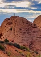
Ant headed out for sunset patrol in the formations around camp. Our neighbors in the loop were in a steep descent towards inebriation. UTVs buzzed through on the spur of the Fins and Things trail. A short time later he emerged atop one of the nearby formations.
Around the fire, there would be no conclusive understanding of the Sandstone Buddha’s riddle. Maybe it was what felt like a superficial nature. Perhaps more thorough internalization of the events that culminated in the seemingly trivial conclusions would reveal a deeper meaning. Perhaps we are just not adept at assigning cosmic significance.
Looking towards our own time to turn towards home we had options; to Great Basin National Park and the Loneliest Road, or up to Salt Lake with a stop at the Land Cruiser Heritage Museum (the most robust collection of Land Cruisers in the world). Ant and I were still totally jazzed from the OEW so LCHM was our legitimate intermediary goal.
As luck would be, our last morning in Moab, the eastern terminus of our travels, would be cloudless, brilliant and hot-ish. Gear was carefully rolled and stowed for the long trip back to the Sierra. Angus’ departure garnered the usual stares of affection and envy. We stopped at an auto part store for some replacement vacuum hose. Ate a spot of breakfast and then goodbye to the desert and the red-walled landscape.
I believe that in my (relatively) short time overlanding that it has taught me something about patience and tolerance. Tolerance framed not only of others who think and act however they do, but of realities. Events happen and there is no level of influence or control that I can exert to change that. Anger and frustration are non-value-added human reactions.
So was the circumstance on Utah route 6, in the coal mining town of Wellington. When a careless driver used incredibly poor judgment and chose to pull out directly in front of Angus, then reconsidered and stopped dead in our path. Leaving no space to maneuver and having no other options I slammed the Landy’s brakes, locked all four wheels, and skidded directly into his vehicle.
Several cars behind us also skidded to a stop or were able to evade the collision. Angus started back up and we pulled into the field beside the road. Ant and I were safe. Angus took the hit for us. My first furious reaction was fast washed over with sadness at the sight of the twisted bumper pressed into the crumpled wing. My heart sank.
The other driver was out of his pickup and walked over to me. It was all I could do just to ask if he was OK. His passenger was busy with whatever farm tool he had trying to straighten the front end enough to move the rig out of the intersection. Ant started taking pictures.
Everyone was in one piece, everything else could be made right again. Before I could dial 911 the state police were on scene. I guess the ruckus of the crash was enough to send the cavalry. One officer started getting the story straight and handed me a clipboard to write my statement. The other officer was there for comic relief. I guess they don’t see too many RHD rigs around these parts. He jokingly suggested that the cause of the crash was the wheel on the wrong side. I was quick to snap back (with equal comic sarcasm) that it was on the left before the accident.
We all walked away. I wished the lead officer and other driver safe travels. We checked the steering to make sure it was unobstructed. Angus drove away with a black eye. The Silverado that tangled with him had its front end dismantled all over the street.
Our drive to Salt Lake City was melancholy. Ant may have been a bit frayed. The trip had been long. Our track record of adventure mishaps was firmly intact. My mood didn’t help. I was shaken, wicked bummed out and probably not the best company. That’s how journeys go. High and lows. Struggles and victories. Moments and disasters.
Amazing is the only way to describe the Land Cruiser Heritage Museum. The detail, the restoration, the diversity of models and dedication to assemble such a collection is simply love. Even through a muted ability to embrace the uniqueness of each specimen I could fully appreciate the care and expertise associated with each truck. Ant has taken a fancy to the FJ40 series. I think this excursion is, in part, research for his next project.


We battled wind and rain for as long as we could. Our last overnight stop would put us in Elko, NV. A thriving mining town along interstate 80. Ant graciously made our arrangements. The probability of opening the RTT in weather after the day’s trials was zero. Elko is the kind of town where you could have a good time, but you’ve got a much better chance of finding trouble. We’d had enough entanglements already. We suffered through bland food in a crappy smoke-filled casino. Matt, our waiter, was struggling through his first day on the job. We tipped him well despite his bumbling. He needed a lift. We needed karma.
The problem with northern Nevada in the springtime is its harsh beauty. Most mountain ranges still wore snow caps. Spotty rain showers sail across the platinum sky and play amongst beams of sunlight that blast through gaps in the clouds. Sporadic splotches of blue-sky peek through. The desert this time of year, especially in a spring as wet as this one, is a green carpet of grasses and sage. The problem (the other problem) is that we do not have in our possession a wide-angle lens large enough to capture it all.
Here we ended where we began. Surrounded by mountains on the high desert. Dodging rain and wind. Perfumed by blooming sage. Pressing on in a battered, but not defeated, faithful Defender. Awed by the valley that opens on the far side of each pass.
Epilogue
In the aftermath, we made it back to base in between snowstorms without further incident. The Landy got a good scrubbing and some TLC. Ant was able to get home to his family a day early. Danny and I keep sending him ‘for sale’ postings for FJ40s. The Utah State Police found the other driver at fault of not yielding the right-of-way. At least Angus gets repaired on his dime.
 We traveled 2,191 miles, covering 4 states, with 2 police interventions, 1 breakdown, 1 accident, dozens of new faces, and 1,998 images captured.
Some key thoughts looking back:
- Angus goes as fast as he wants to. When you push him, he gets grumpy. When you push hard, he throws a temper tantrum.
- There is always room for improvement when it comes to leaving gear at home. We’d done much better this expedition than others but could still shed another 100-200lbs of unnecessary items.
- Dragging along bicycles, and bicycle crap, just to ride in the last few days of a multi-week trip was not the brightest idea. Leaving bikes and associated gear behind (and renting instead) would have saved another 150lbs.
- We didn’t schedule down days. Rule of thumb is 4 days on 1 day off. In special locations more. We should have planned some downtime days. We crammed a lot of travel into a very finite time.
- For extended trips plan for cold and wet. Ensure waterproof gear is up to the task.
- Never underestimate the need to clear, active, driver-passenger, partner communications. I still need to be better.
We have yet to agree on what the Buddha in stone was trying to tell us.
Check out all of our pics in the expedition photo gallery.
About the Author:

One thought on “Quest of the Sandstone Buddha”