
A bright, brisk Sunday morning. The loose plan for the next week: explore the North Rim of the Grand Canyon,  check out the Grand Staircase or Zion if time allowed, meander west across Nevada, and meet up with the rest of the team somewhere in the Sierras.
Step 1: resupply and refresh all of our gear and supplies. Danny had the brilliant idea to visit the community pool so we could strip away a few layers of dust and let the boys jump around in the water for a while. The funny thing about Flagstaff is that they don’t have a  community pool, they have an Aquaplex, and one does not simply visit the facility, you experience it. (Conveniently, there is a full-service Laundromat across the street and ample supermarkets to meet the rest of our supply needs)
Our first North Rim destination within striking distance was Point Sublime within the GCNP. All but the last 20miles was expected to be on pavement. Once on the Point Sublime trail, much of it was smooth yet pretty dusty. The short rocky climbs and descents were nothing anyone would consider challenging. Fortune shined upon us as one of the two established camp areas on the point was a no-show. The other was an OEW attendee from Wyoming, traveling the southwest, as we were, in their Alaskan cab-over.


Sunset was muted by a thickening cloud cover. Dan had partially dropped and dragged one of his mountain bikes on the trail and heavily damaged the cockpit controls as well as brake and shift cables. Rio and Bear were both required to take on independent study due to the length of the trip removing them from class. Home study was a nightly ritual often conducted by lantern and headlamp.
Sunrise at 5:15. Up early to take advantage of the best photo lighting but ended up a little disappointed because of the cloud cover.


The route to our next point was going to be through a rat’s nest of forest service roads. We dropped GPS waypoints at every turn so we’d have a trail of breadcrumbs if we needed to find our way back.

It may have only been about 40 miles or so to our planned point, a place called Indian Hollow, but it consumed a considerable number of hours to get there. Upon arrival, it was clear that we’d gambled on this location and come up short. It was hot, dry, sheltered (so no breeze), and infested with insects.
Dan and I sat down a picnic table with the Gazetteer to weigh our options. On the map, there was a spot to the northeast labeled Sowats Point. There was no developed space identified, just a road that terminated at the point. Highly promising. Everyone was a little tired and it looked like about another hour of driving but decided that it best to roll the dice.
The traverse out to Sowats is straightforward. The road emerges from the forest and the terrain becomes a savannah. As we approached the end the road split into 3 separate points into the canyon, each in its own isolated point on the rim. The road clearly had not been driven in some time. Our choice to select this location proved to be the best of the entire experience. The space at the end of the road was relatively flat, exposed, and loaded with prickly pear, but with a 270-degree view of the canyon. This will go down as one of the top-3 locations we have made camp anywhere.
Happy hour was blissfully quiet. Nothing but the wind made any noise. Bear and Rio did schoolwork. Danny was under the truck making secure some of the new cabling that had started to hang below the frame, begging for a rogue root to hook-up and rip it from the chassis.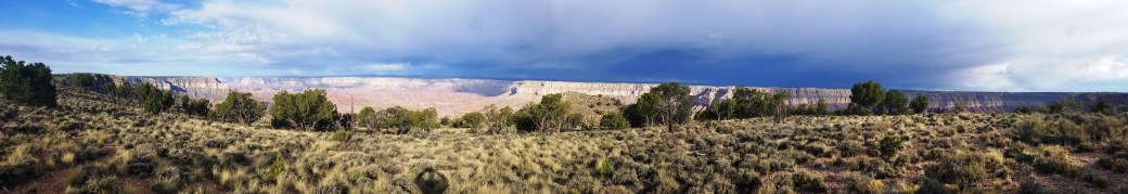


Sunrise came with the crack of thunder and lightning. Kind of amazing given the intensity of the current drought in AZ. We were exposed and the storm was close. All four of us retreated to the relative safety of the truck cabs. The sunrise rose behind us enabling the canyon colors to pop while the rain caused numerous rainbows with the dark sky in the background.


Once the storm passed I took Bear and Rio for a hike down to the rim. They were both pretty excited about the geology and couldn’t get enough of crystal rockhounding.

Continuing west along the rim would require us to depart the North Rim, turn the corner at Fredonia, and then back south to SB Point back in the GCNP. What we didn’t know before starting out is that most of the travel along the rim was through dense forest, not open vistas. (This closely resembled my earliest off-road days in the Meshomasic State Forest in the Northeast)  We had been on the rim for a few days and since Fredonia is halfway to Zion NP (where neither Dan nor Rio had ever been) we called for a change in venue and headed north to Utah.
Springdale is an interesting place. It has grown to meet the hordes of tourists as the popularity of Zion has grown. High-end accommodations and dining have replaced the character of the town and pushed many of the locals to Virgin and Hurricane. Same story as many other resort towns in the Western US.
We posted up for a few days in the urbanest of camp locations. Luck would play out for us again at the banks of the Virgin River where the dudes played in the river while Danny and I repaired and cleaned equipment.


For anyone visiting Zion, the standard (almost required) experience is to hike The Narrows. Every outfitter rents canyoneering equipment for this activity.


Over multiple visits to the park, this has transformed from an enjoyable hike to a Congo-line dancing up the river. The human carrying capacity of the park has been well exceeded and will at some point require additional throttling to maintain and control of eco-degradation.
Overall the people are still friendly despite having to tolerate the endless touring masses (of which we have become).


One note of importance is the original and for more than a decade the only, bike shop in Springdale – Zion Cycles. It has seen several owners and continues to deliver great service. In our case, they were able to put Dan’s damaged whip back together with quick however considerable effort.
Back at full strength and on the move again, we could not pass up the opportunity to take a lap on the Guacamole network before turning west to start heading back towards Cali


The great thing about exploring places like Utah and Arizona (a little different than other locations that we’ve traveled before) is that there is always something to come back to that is new. From this mission, we have a need to finish the North Rim west of Kanab Creek through Mt Trumbull. Additionally, the less utilized, and still fantastic, Kolob Terrace demands to explore as does several more loops through the Guacamole network.


Keeping with the adventurous overtones led us to some of the most remote parts of Nevada on our westbound return. Most interesting, and entertaining by far, was the town of Rachel. The Town of Rachel was founded in 1973 and boasts being the closest community to famed Area 51 (25 miles to the south). From its heyday of 300 people, Rachel now is home to less than 100. Many of whom apparently enjoy being isolated from the civilized world. This is, with exception to the half-dozen we met in the Little A’Le’Inn bar and restaurant who were friendly, day-drinking shit-faced hilarious, and happy to entertain us. The building is lined with photos of UFOs and test planes known to have been developed at Area51, intermingled with kitschy UFO crap for sale.


Pushing forward past the Extraterrestrial Highway we made our way through Tonopah and Hawthorne to Walker Lake just before dark and passing thunderstorms. This would be our last night together as a caravan.
On the final day together heading back towards the Reno area, in heavy rains, we detoured off the path one more time up six-mile canyon road to Virginia City, a sizable living ghost town outside of Carson City so the guys could stretch legs and walk around one more time.
From there Bear and I parted company with Dan and Rio. A great adventure, a really good time. No injuries, no breakage, more elements of the journey went right than went wrong. So by all accounts a smashing success.
Our last destination before getting back to the North Shore was to meet up with our other half at Lake Davis in the Northern Sierra, where snow was not expected to fall that evening. With Gandalf resupplied, we prepped for their arrival. It was wonderful when Darla and Finn arrived with other friends in tow.
Trip statistics:
- Days Total: 12
- Distance Traveled: 1750.7 Miles
- Fuel Consumed: 109.019 gals
- Mileage: 16.058 miles/gal
Trip impressions:
What a great exercise in planning and executing an overland trip. Very few problems with vehicles and equipment on the road let us focus on being in the moment. I think that next year there will be a much shorter tenure at OEW unless something changes. There is unfinished business in Zion and North Rim to be attended to. Also, there are a number of locations in UT that need to be visited outside of the National Parks such as Bear Ears, Grand Staircase, Kodachrome, Anasazi, Monument Valley, Valley of the Gods, etc. etc. Let’s see how those play out for next year. I feel that we are ready for a bigger time commitment to the journey.
Lessons Learned
- Like most overland excursions we over packed. Bring less stuff than you think you need. Less is more, less is more, less is more.
- We had some power management issues using our ARB fridge/freezer. Identified a number fixes to our power problems:
- Solar panel kit now goes everywhere with us
- All power needs get routed through Goal Zero solar generator (keeping to 1-power draw off the battery)
- Shut down all peripherals when in camp, i.e. GPS, Tablets, etc.
See all of our North/Westerly photos in the gallery: A post-expo Adventure

About the Author: